EOS1080 : How to Draw a Cross-Section of a Map – Geology of Ireland : Earth and ocean, Assignment, Ireland
| University | University Of Galway (UOG) |
| Subject | Earth and ocean Assignment |
How to Draw a Cross-Section of a Map
Step 1
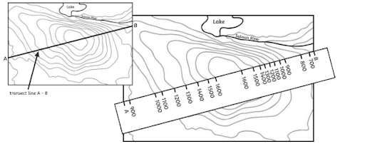
Take a thin strip of paper and place it along the transect line on the map. Mark A at the start of the transect and B at the end. Where each contour line crosses the strip of paper, make a mark on the paper at the exact point and record the height. Also mark on any roads or rivers etc.
Step 2
On a piece of graph paper, draw the horizontal axis of your graph exactly the same length as the transect A-B. Remember to use a ruler and pencil!
Step 3
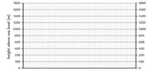
Draw two vertical axes using a suitable scale. Check the maximum height of your axes by looking at the heights along the transect. In this example, the axes need to be at least 1600m high as this is the highest point on the map. Label your axes.
Step 4
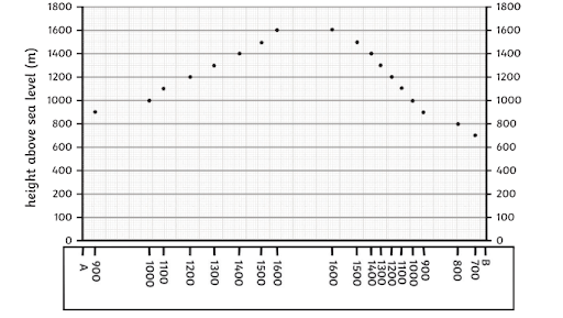
Place the strip of paper along the x-axis at the bottom of your graph. Line A and B up with the vertical axes.
Step 5
Plot the heights marked on the piece of paper onto the graph. You can move the paper up the graph but make sure the A is always lined up with the vertical axis!
Step 6
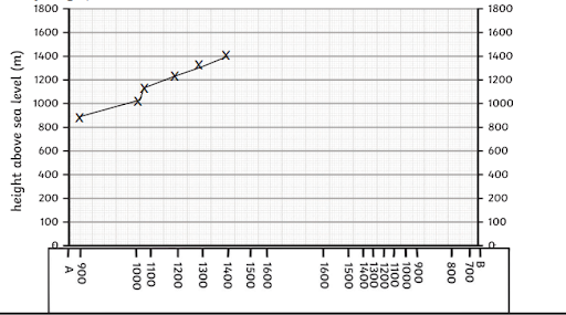
Using a pencil, draw a smooth line to connect the dots. This will give you a rough estimation of what the landscape is like.
Step 7
Add a title to your graph.
Cross- Section of Mt.Ain
Are You Searching Answer of this Question? Request Ireland Writers to Write a plagiarism Free Copy for You.
A profile across a subduction zone
Introduction
During the Ordovician, Ireland was at the edge of a converging tectonic plate, where
subduction was taking place. Today, we see something similar in the Andes.
Aim of practical
Your task in this practical is to draw profiles (in a cross section) across the Andes, from –
75°E -20°S to -65°E -15°S which illustrate the shape of the crust, and the position of
the subducting slab. You will then identify certain key regions in the zone and label them.
Method
If you are not familiar with how to draw a cross section from a topographic map, the link
that I have given you on Blackboard gives very clear instructions (I don’t need to re-invent
the wheel here!). The only thing to note is that for our exercise we are working with depths,
not heights, so the numbers increase downwards (I’ve already put them in in Figure 1 for
you)
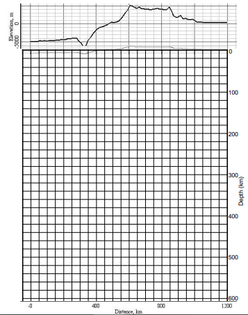
1.A bathymetric and topographic profile is already done for you showing the depth to the
sea floor and the elevation of the land along the cross section line (Figure 1; marked with
X – X’ on Map 1 – you will need to mark the points on Map 2).
2.Use the information in Map 1 to draw the depth to the top of the downgoing slab in your
cross section.
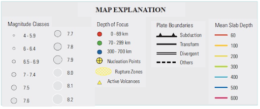
Map 1 shows the seismic (earthquake) activity in the region – the dots mark
earthquake foci (where the earthquake rupture starts) and are colour coded to
indicate how deep the focus was. Note that as you move away from the trench,
the earthquakes get deeper – so we know that the oceanic plate is going
underneath the continental plate (as we’d expect, given the density contrast).
The coloured lines are contour lines for the top of the downgoing slab. You use
them to draw this part of your profile.
3.Assume that the slab is 70km thick (and this is perpendicular to the surface) draw in
the bottom surface of the slab. This is very approximate, don’t agonise about it!
4.The information in Map 2 shows the depth to the Moho – i.e. the base of the crust – in the
over-riding plate. Using the same method as before, transfer this information to your
cross-section. Your line will pass close to but not cross some of the contours (the 40km
and 70km) – you can extrapolate a little here and mark them on your profile .
5.Some of your lines will be left finishing in ‘mid-Earth’ (rather than mid-air) on your
profile – so now you need to use your geological knowledge to tidy up the section. Think
about what the lines mean – e.g. there has to be an edge to the over-riding plate; the
oceanic plate has a base too (and we have the top because we have the sea floor)
6.Have a look at the questions on the final page to see if you can mark various
points/regions on the cross section.
Get Solution of this Assessment. Hire Experts to solve this assignment for you Before Deadline.
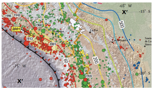
Map 1: Seismic and volcanic activity, and slab depth in a region of the Andes
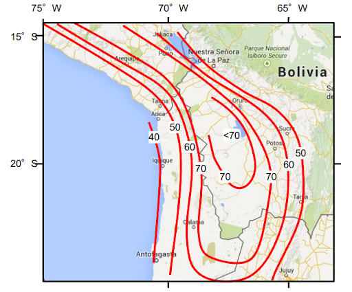
Map 2: Depth (in km) of the Moho (base of crust) in the Andes
Figure 1: Bathymetric and topographic profile from -75E -20S (0km) to -65E -15S (1200km)
Note the different vertical scale for the subsurface features, because, if the same scale was
used as for the bathymetry and topography, there would either not be enough space on the
page to do the full profile, or the topography would be negligible. I’ve duplicated (faintly)the
bathymetry/topography at the subsurface scale to give you an idea of how minor it is. Note
also that 0m elevation/ 0km depth is marked twice.
Stuck in Completing this Assignment and feeling stressed ? Take our Private Writing Services
Need assistance with your Earth and Ocean assignment? Our assignment help Ireland service is the perfect solution for you! Irish students can easily pay to do my assignment for me and receive expert guidance on their coursework. Enjoy affordable, high-quality Homework writing services with 100% human-written content—no AI involved! We guarantee on-time delivery and plagiarism-free Assignmnets, ensuring you achieve the A+ you aim for. Get the help with geography assignments you need today!